All tagged nws morehead city
National Weather Services shared graphics on social media to address early chatter about potential wintry weather next week, with Wednesday being a tentative focus. It’s too soon for a briefing, but sharing these posts helps spread consistent and accurate messaging as the situation evolves.
Please see the latest briefing on Hurricane Debby. There is little change in the threat assessment for Eastern NC at this time. Debby is forecast to move slowly across northern Florida and into southern Georgia today into tonight, and then move very slowly across or just offshore of the Southeastern U.S. through the rest of this week.
Minor to moderate coastal flooding is forecast for soundside locations from the northern Outer Banks southward to Frisco. Additionally, wind gusts of 45-50 mph are likely along the coast and near 40 mph for inland areas. A widespread 2-3" of rainfall is expected but a flash flood threat remains negligible.
A low-pressure system off the Southeast coast will bring significant impacts to Eastern North Carolina from Friday through Saturday. The storm's expansive wind field extends beyond its center, increasing the risk of scattered tree damage and power outages. Coastal areas may experience storm surge and inundation of up to 2-5 feet, while widespread rainfall of 3-5 inches (with localized totals up to 7 inches) poses a flash flooding threat, especially in urban and poorly drained areas. Additionally, the storm carries a risk of several tornadoes, with potential damage and disruptions to power and communications. Residents are urged to exercise caution, avoid flooded roads, and stay informed about this evolving weather system.
Primary Threats: Minimum heat indices of 105 each afternoon, with values in excess of 110 degrees possible on Monday.
Ian is now a strong Category 4 hurricane located about 75 miles WSW of Naples, FL. No major changes were made to the forecast track overnight - Ian is still expected to make landfall today along the west coast of Florida, around the Port Charlotte area, and slowly track NE across central FL tonight and Thursday.
As a result of Hurricane Earl, we will continue to experience an extended period of life threatening rip currents for all Eastern NC beaches through this weekend and likely into early next week. In addition the combination of onshore flow, high astronomical tides, and Hurricane Earl swell will lead to minor oceanside coastal flooding again around this evenings high tide. A HIGH RISK for Rip Currents continues for All Beaches today.
Sunday: The main threats will be damaging wind gusts and large hail. An isolated tornado will also be possible. Torrential downpours will occur in the strongest storms as well. Timing will be from mid afternoon into the evening (3-11 PM).
Monday: Heat Index values up to 105 degrees are expected.
Tuesday: Heat Index values up to 105-115 degrees and severe thunderstorms are also possible.
Tropical Storm Alex has formed this morning, but will continue to move away from the Southeast US this week. However, swell from this system will reach the NC coast later today, and an increased threat of dangerous rip currents is expected through at least mid week.
Advisories have started on PTC One in the southern Gulf of Mexico, which is expected to become Tropical Storm Alex later today. This system is expected to pass through southern Florida and then emerge into the Atlantic and pass several hundred miles south of NC Sunday.
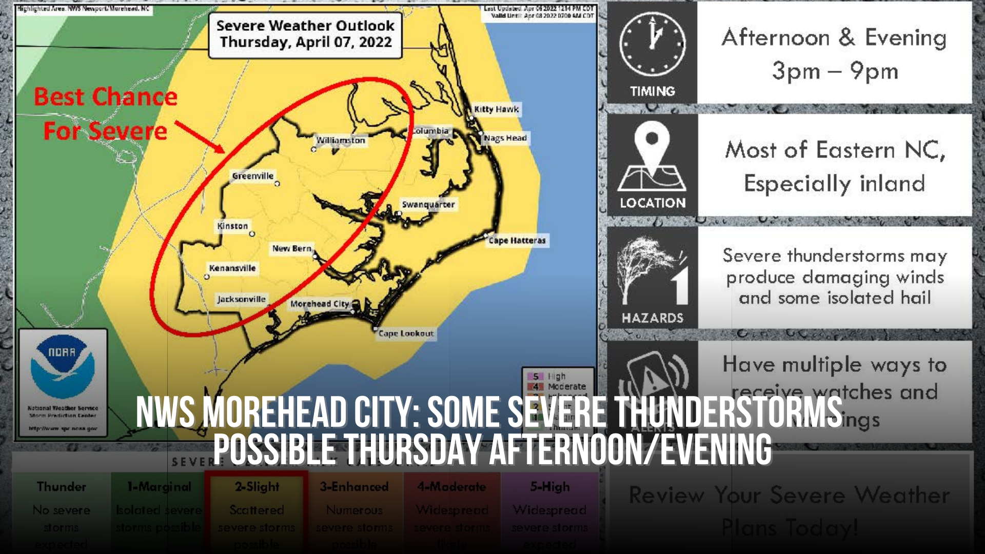
Showers and some storms are possible tonight, but a better threat for a few severe thunderstorms arrives later Thursday afternoon and into the early evening ahead of a cold front. The best chance for a severe storm will be inland Eastern NC.
The biggest threat remains severe weather both ahead of and along the cold front from early Saturday morning through Saturday afternoon.